


Gandhinagar, Aug 7: Every monsoon, India’s rivers turn brown. To most of us, that colour simply means muddy water. But hidden within it is the material that builds fertile floodplains, creates river islands, nourishes deltas and even shapes coastlines: sediment.
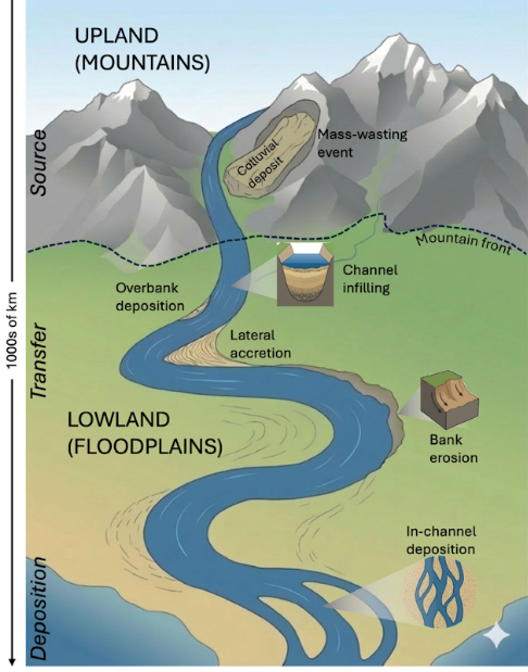
Sediment is the sand, silt and clay that rivers carry from the mountains to the sea. Without the movement of sediment, many of the landscapes we depend on simply would not exist. Floodplains would lose their fertility, river islands would disappear, and deltas that support millions of people would gradually shrink.
Think of a river as a giant conveyor belt stretching from the mountains to the coast. Water keeps the belt moving, while sediment is the cargo travelling on it. Every bend, sandbar and delta exists because this cargo is constantly being picked up, carried downstream and deposited elsewhere. Sandbars are long, narrow ridges of sand that form in oceans, lakes, or rivers when moving water deposits sediment.
However, this journey is being altered in unexpected ways. Sometimes nature overwhelms the system with enormous amounts of sediment. At other times, human interventions stop sediments from reaching their destination. Two recent studies in contrasting landscapes involving researchers from the Indian Institute of Technology Gandhinagar, one on the Brahmaputra River, eastern Himalaya and another on the Godavari River, peninsular India, discuss these aspects. Understanding them may be key to managing floods, protecting coastlines and preparing India’s rivers for a changing climate.
The first study involves IITGN researchers in collaboration with those from the University of Leeds, examining the Eastern Himalayan Syntaxis in the Brahmaputra basin. This region experiences some of the highest erosion rates in the Himalaya, wherein earthen materials are worn away and transported by natural forces such as water. Their findings were published in Earth Surface Processes and Landforms.
One of the largest rivers in the world, the Brahmaputra originates on the Tibetan Plateau, and after entering the Himalaya, it flows as the Siang. Downstream of Pasighat, the river adopts a braided form and flows as the Brahmaputra before draining into the Bay of Bengal. It is a sediment-laden river with an annual sediment load of 500 to 1000 × 106 tonnes/year. Think of it as being roughly similar to the weight of approximately 2.5 to 5 million blue whales!
In recent decades, the Eastern Himalayan Syntaxis has been the site of four major mass-wasting events: the 2000 Yigong event and the 2017, 2018 and 2021 Sendongpu events. While the Sendongpu valley lies within the Eastern Syntaxis, the Yigong site is about 50 km away, located along the Yigong River.
“We analysed years of satellite observations of the Brahmaputra following these events, tracking changes in water turbidity, water surface elevation, sandbar area and flood extent, at the finest temporal and spatial resolution available through Google Earth Engine’s database. The findings were remarkable. Fine sediments from the mass-wasting events could be traced up to approximately 1000 km downstream, reaching the delta,” remarked Dr Abhishek Dixit, a postdoctoral fellow in the Department of Earth Sciences at IITGN and the first author of this study. One can imagine this long distance as similar to being that for a road trip between Ahmedabad in Gujarat and Bareilly in Uttar Pradesh , or flight travel from London to Venice!
Picture pouring both sand and pebbles into a flowing stream. The sand would travel further with the water, while the pebble would settle much sooner. In a similar manner, coarser sediments from the Brahmaputra accumulated within about 100 kilometres of the mountain front. This morphological change coincided with increased water surface elevation and high flood inundation. The latter involves the covering of dry land by an overflow of water. Upon comparing the Yigong and Sendongpu events, the team realised that the character of an event defines the river’s response. The former led to far-reaching but short-lived sediments while the latter produced a prolonged but less intense response, with sediment retained in valleys and gradually mobilised over time.
These ‘sediment’ changes matter. A channel partly filled with sediment may have less room to accommodate rising water. New sandbars may divert the flowing water into different paths. The study found that the stretch of the Brahmaputra just downstream of the mountains experienced a significant increase in flood extent following the 2017 event. Further, the 100 km reach showed an increase in sandbar area of between 20% and 35%. Such information highlights the need to integrate mass-wasting-driven sediment movements into flood risk assessments and hydropower planning in landscapes that are increasingly subject to both natural and anthropogenic pressures.
Changes in sediment travel may be one of the reasons behind the current situation in the Indian state of Assam, which is facing the worst floods in years. Sediments are likely to reshape river systems in ways that we have not yet been able to fully observe or predict.
The Godavari River appears to show a different side of the tale. Stretching nearly 1,500 kilometres across central and peninsular India, the Godavari supports millions of people before falling into the Bay of Bengal. For centuries, the river transported vast quantities of sediment from the Deccan Plateau to its delta. Every monsoon, fresh layers of sand and silt replenished floodplains, nourished farmland and sustained the delta.
However, this natural supply chain has been interrupted by the construction of over 900 dams. IITGN researchers examined sedimentation rates from 48 major dams and sediment load data from 23 gauging stations in a new study. Their findings were published in Anthropocene.
Dams store water for irrigation, generate hydroelectricity, reduce drought vulnerability and support drinking water supplies. However, they also alter the way rivers function.
According to Dr Dixit,
“Our findings revealed that between 1969 and 2013, the amount of sediment flowing through the river in a year declined by about 115 million tonnes, while reservoirs accumulated around 101 million tonnes annually.” In other words, the sediment missing downstream was similar to the amount being trapped behind dams.
Imagine a busy highway where many trucks and some cars transport supplies from one city to another. Now imagine a huge checkpoint built across the road. The trucks carrying the cargo are forced to stop, while cars continue to the destination. Dams work in a similar manner. Water continues flowing downstream, but much of the river’s cargo, which are sediments, gets trapped in reservoirs instead of completing its journey to the sea.
The consequences become most visible at the deltas. The study suggests that sediment replenishment has weakened dramatically in the delta, which retains only 20% of the incoming sediment. The researchers estimate that dam traps would cause the river to sustain only about half the delta area that could have been maintained before dam construction. Parts of the delta may become increasingly vulnerable to issues like erosion and rising sea levels.
According to Professor Vikrant Jain,
“Future research may consider investigating how multiple drivers, such as changing land use and groundwater extraction, could interact to alter sediment connectivity across different river basins. Moreover, the findings from these two river systems cannot be generalised to all Indian rivers, each of which has its own characteristics.” Professor Jain is a faculty member in the Department of Earth Sciences at IITGN. He also heads the River Earth and Environment lab at the Institute.
Both these studies, which view rivers as systems that carry materials needed to shape landscapes, are a reminder that sediment is a crucial piece of the puzzle. “While on the one hand, events like heavy rainfall may increase the chances of landslides, influencing the generation and transport of sediments by rivers. On the other hand, the country’s demands for water storage and hydropower, resulting in the building of reservoirs, also have the potential to alter sediment pathways in ways that ripple far downstream,” continued Professor Jain.
Understanding these pathways may help guide flood-risk assessments and hydropower planning, and inform strategies to protect landscapes like deltas.
These studies are in alignment with India’s priorities, including elements of the National Mission for Sustaining the Himalayan Ecosystem, the National Disaster Management Plan, and broader river management initiatives. They also resonate with aspects of the United Nations’ Sendai Framework for Disaster Risk Reduction.
The researchers acknowledge funding support to Dr Dixit through the project ‘Major Research and Development Programme in Hydro Climate Extremes’ funded by the Department of Science and Technology, India, and the Building Resilience to South Asian Water Challenges Through Investment in Tomorrow’s Talent project under the University of Leeds International Strategy Fund.