April 09: India has 18 percent of the world’s population but only about 4 per cent of global freshwater resources, and nearly 600 million Indians already live in areas of high to extreme water stress. Almost half of the country’s farmland depends directly on rainfall rather than irrigation, making crops highly vulnerable when monsoon rains fail or heatwaves persist. In this context, a new scientific cooperation between NASA and the Budapest University of Technology and Economics (BME) aims to improve the global soil-moisture satellite data quality that can underpin drought monitoring, crop-yield forecasts and climate-risk models in countries such as India
The collaboration focuses on validating satellite-based soil-moisture measurements, a key parameter of climate and hydrological models. “In India, as in Central Europe, what happens in the top ten centimetres of soil can decide whether a heatwave lingers uncomfortably over the area or turns into a serious crop-loss and water-security problem,” says Dr Zsófia Kugler, associate professor at the Faculty of Civil Engineering, Budapest University of Technology and Economics and head of the Department. for Photogrammetry and Geoinformation, “Our role is to make sure the satellite data that feeds these models is as reliable as possible.”
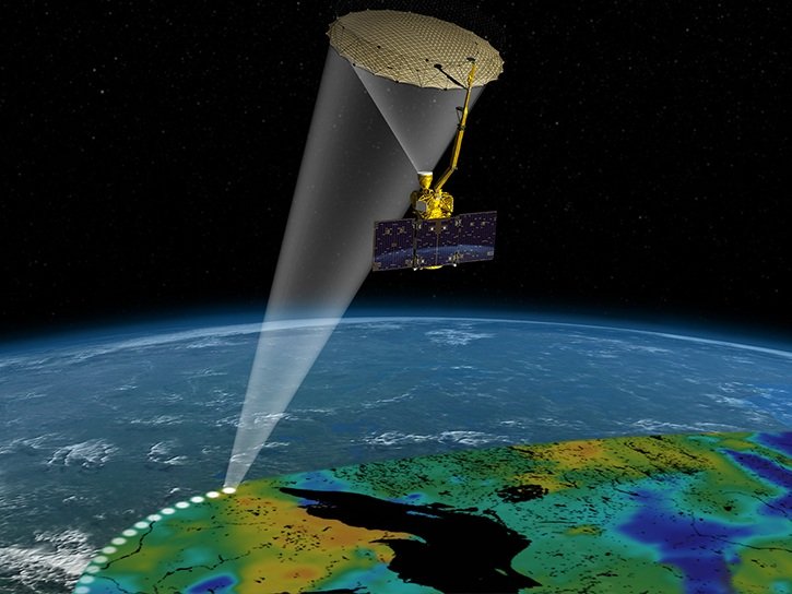
Under the cooperation, BME provides NASA with detailed soil-moisture time series from Hungarian in-field sites, along with technical expertise in interpreting L-band microwave signals over different soil types and vegetation covers. These datasets are compared with satellite products from missions such as SMAP and NISAR, helping scientists understand where and why satellite estimates may differ from reality. Because satellites scan India every few days, improvements in their algorithms also benefit Indian applications, from monsoon-season drought monitoring to irrigation planning for rain-fed crops in states such as Maharashtra, Karnataka and West Bengal
Accurate soil-moisture data from satellites can therefore support several applications relevant to India, including seasonal crop-yield assessments and food-security planning, irrigation scheduling and regional water-allocation decisions, early warnings of prolonged dry spells and heatwaves, as well as improved inputs for climate and monsoon prediction models
By helping to validate and enhance global soil-moisture products, the NASA–BME cooperation contributes to more reliable data streams for Indian agencies, researchers and companies that use satellite information in agriculture, water management and climate-risk analysis
BME’s English-language master programmes in civil engineering, along with specialisations in remote sensing, geoinformation, hydrology and water management, draw on this expertise, offering future engineers a combination of strong theoretical foundations and hands-on project experience with satellite data and numerical models. For Indian students interested in climate resilience, water security and space technology, our programmes provide skills directly relevant to the challenges their home country faces
At BME, the research topics range from drought monitoring to flood-risk management, and these issues closely reflect the challenges that Indian engineers face in monsoon-affected, water-stressed regions. By training students and continuously refining the data they work with, the cooperation aims to make a small but fundamental contribution to building more resilient societies both in Central Europe and in India.